


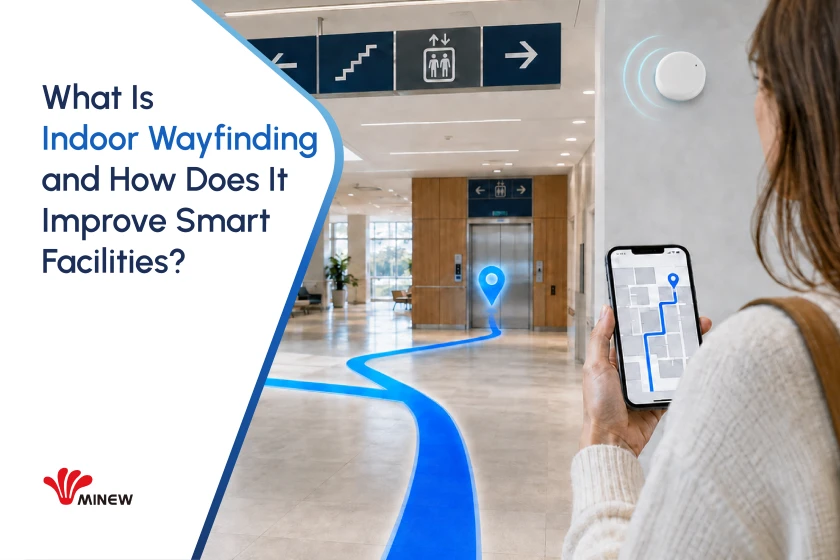
A visitor arrives at a hospital with ten minutes to reach an appointment. Clinics span several floors, and similar corridor names add confusion. A wall sign points toward one department, but it cannot tell the visitor where the journey starts, which elevator to use, or whether that route is still open.
The visitor needs more than another arrow. They need answers to three simple questions: Where am I now? Which route should I take? What should I do at the next decision point?
Indoor wayfinding provides those answers. It connects the building map with location data, route rules, and clear instructions. The result is a guided journey that can adapt to the visitor, the destination, and current building conditions.
What Is Indoor Wayfinding?
Indoor wayfinding is the complete process of helping someone understand an indoor space and reach a destination. A digital system usually combines a searchable map, a starting position, a routing engine, and directions shown on a phone, website, or kiosk.
For example, a patient searches for “Radiology.” The system identifies the correct department, locates the patient near the main entrance, and creates a route through Building B. If an elevator is closed, it can select another accessible route. Instructions such as “Turn left after the pharmacy” confirm each step.
A floor plan shows what exists. Indoor wayfinding turns that information into a journey someone can follow.
How Does Digital Indoor Wayfinding Differ From Traditional Signs?
Traditional signs give the same instruction to everyone. Indoor wayfinding gives guidance based on the user’s position, destination, route needs, and current building conditions.
The differences become clearer when the two approaches are compared by the same navigation task.
| Comparison point | Traditional signs and directories | Digital indoor wayfinding |
| Starting position | Visitors must find a “You are here” marker and match it with their surroundings. | The system can estimate the user’s position or set a known starting point through a QR code. |
| Destination search | Signs list selected departments, services, or room ranges. Visitors must interpret the naming system. | Users can search by department, service, room number, or a familiar term and reach the correct destination. |
| Route choice | Signs provide one general direction, regardless of where the visitor started or what route they need. | The system calculates a route from the actual starting point and can account for floor changes, restricted areas, and step-free access. |
| Building changes | A sign remains unchanged until staff replace or cover it. | An approved map update can reflect a moved department, closed corridor, or elevator outage across all connected interfaces. |
| Journey feedback | Signs cannot show where visitors get confused or abandon a route. | Privacy-aware data can reveal difficult junctions, common searches, and unclear destination names. |
Traditional signs still play an important role at entrances, elevators, and corridor junctions. They provide fixed visual confirmation. Indoor wayfinding adds search, personal route calculation, current building information, and journey insight. Together, they create a clearer navigation experience than either method can provide alone.
Indoor Mapping, Positioning, Navigation, and Wayfinding
These terms describe four different layers of one visitor journey.
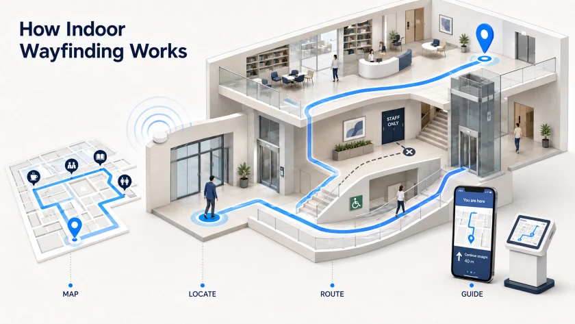
Indoor mapping creates the building model. It records where rooms, corridors, entrances, elevators, stairs, and services are located.
Indoor positioning finds the starting point. It estimates that the visitor is near the main entrance on the first floor.
Indoor navigation technology calculates the path. It connects the entrance to Radiology and produces instructions for each turn and floor change.
Indoor wayfinding creates the usable experience. It combines search, map, position, route, landmarks, accessible choices, physical signs, and arrival confirmation.
Mapping provides the space. Positioning provides the location. Navigation provides the path. Wayfinding brings them together so the visitor can complete the journey.
How Does an Indoor Wayfinding System Work in Practice?
1. Convert the Building Plan Into a Routable Map
The project team collects floor plans, CAD files, room lists, and access rules. A mapping specialist turns them into a digital map with searchable destinations and connected paths.
Corridors, doors, stairs, elevators, bridges, and entrances must link correctly. The map also labels step-free paths, staff areas, security checkpoints, and access limits. The result is a map that routing software can use, not simply a floor plan on a screen.
2. Establish the User’s Starting Position
GPS works well outdoors, but walls and roofs can block satellite signals. Reflections can also reduce accuracy, according to GPS.gov. An indoor project therefore needs another way to establish the starting point.
For fixed-start guidance, a visitor scans a QR code at an entrance or kiosk. The system uses that known point as the route origin, but the position marker does not follow the visitor.
For live guidance, a facility can install Bluetooth Low Energy beacons. A phone detects nearby beacon signals, and positioning software compares the readings with known beacon locations.
The indoor wayfinding system integrator surveys the site, installs and records each beacon, configures its radio settings, and tests real phones at corridors, junctions, and floor transitions. Placement should follow the navigation task, not a fixed spacing rule.
3. Apply Route Rules
The routing engine receives the origin, destination, and user needs. It then selects a valid path.
A visitor route may avoid staff areas. An accessible route may exclude stairs. An airport route may respect security zones.
Authorized facility staff manage these rules. If a corridor closes, they mark the path unavailable so new routes avoid it.
4. Deliver Instructions Through the Right Interface
A first-time visitor may open a mobile website through an appointment link or QR code. Employees may use an existing workplace app. A kiosk serves people who do not want to use a phone.
On each channel, the user searches for a destination, confirms the correct place, sets the starting point, and receives the route.
With live positioning, the system updates the location marker and recalculates after a wrong turn. Without it, the system still provides directions from a known entrance or kiosk.
Why Indoor Wayfinding Matters to Smart Facilities
A Lower Friction Visitor Journey
Visitors spend less time reading directories, backtracking, or asking for help. Guidance can start in a parking area and continue across buildings and floors to the final room.
Less Staff Time Spent Giving Directions
Receptionists, security staff, and clinical teams often answer the same questions many times. Self-service guidance reduces that repeated work. The same map helps employees and contractors find rooms, equipment areas, and service locations.
Routes That Reflect Accessibility Needs
The shortest route is not suitable for everyone. Some users need elevators, ramps, or accessible entrances. Digital routing can offer these choices when the map contains correct accessibility data.
Location Insight for Better Operations
Privacy-aware analytics can reveal common searches, abandoned routes, and difficult junctions. Teams can use these patterns to improve signs, map content, and staffing.
Indoor Wayfinding Use Cases Across Industries
Hospitals and Healthcare Campuses
Hospitals contain several buildings, repeated department names, controlled doors, and clinics that move. Like Minew did in HongKong Hospitial, visitors may arrive stressed and short of time.
Indoor wayfinding guides them from parking or reception to the correct clinic, lab, pharmacy, or accessible entrance. An appointment link can open the route before arrival.
Multi-Level Parking Facilities
Large parking garages often have similar-looking floors, weak GPS signals, and few memorable landmarks. In a real-world pilot at Toyota’s corporate campus, Minew BLE beacons and Navigine software supported positioning and navigation for both drivers and pedestrians.
Airports and Transportation Hubs
Passengers move through check in, security, gates, baggage areas, and ground transport under strict time limits. Static signs show general flows but cannot calculate a personal route.
Digital guidance connects terminal floors and updates the path when a gate or access point changes.
Universities and Corporate Campuses
Campus room codes often make sense to facility teams but not to visitors. Meetings also move between buildings.
Indoor wayfinding connects entrances, classrooms, meeting rooms, desks, and services. The same map helps maintenance staff find equipment and work order locations.
Shopping Malls and Retail Spaces
Store directories become outdated when tenants move. Shoppers may not know which entrance or parking zone is closest.
A searchable map guides them to shops, services, and parking, while search patterns reveal difficult destinations.
Events, Exhibitions, and Temporary Venues
Event layouts change quickly. Booths, stages, entrances, and restricted areas may differ each time. Printed maps can become wrong before opening.
Organizers can update digital destinations and routes centrally, then publish them through a mobile site, app, or kiosk.
How Should You Choose an Indoor Wayfinding Solution?
A useful buying process turns user journeys into technical and operating requirements.
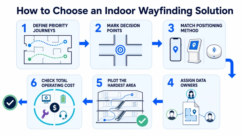
Step 1: Select the Journeys That Matter Most
List the user groups and routes that cause the most confusion or staff work. A hospital may start with parking to outpatient clinics. An airport may choose security to gates.
Record each starting point, destination, floor change, restriction, and accessibility need. These journeys become pilot test cases.
Step 2: Set Accuracy From Real Decision Points
Do not ask for “high accuracy” without context. Define the decision the user must make.
Zone-level positioning may be enough to identify the correct wing. Choosing between nearby corridors requires the system to distinguish the junction. Identifying a specific door or asset may need finer accuracy.
Mark these decision points on the map. Ask vendors to demonstrate performance there during busy periods and floor transitions.
Step 3: Match the Positioning Method to the Journey
QR codes or kiosks may be enough for routes from known entrances. BLE beacons suit many phone-based projects that need position updates. Other technologies may fit finer location needs or dedicated tracking tags.
Compare device compatibility, installation, tested accuracy, battery service, calibration, and total cost. Do not choose from an accuracy claim alone.
Step 4: Assign Clear Data Owners
One team should own the map after launch. In a hospital, this is often facilities management, space planning, or digital operations. Airports may assign terminal operations or a geographic information team. Campuses may use facilities, workplace operations, or IT.
Department managers confirm names and opening hours. Security approves restricted routes. Accessibility staff review suitable paths. IT manages access, integrations, privacy, and security. The integrator may maintain beacon settings and positioning software.
Each change needs an owner, approval path, and target publication time.
Step 5: Pilot the Hardest Representative Area
Choose a difficult area with several floors, similar junctions, dense walls, crowds, or nearby elevators.
Ask first-time visitors to complete priority journeys without coaching. Measure successful arrivals, wrong turns, journey time, and requests for help. Test accessible routes separately.
Step 6: Check the Full Operating Cost
Review map updates, software fees, integrations, beacon installation, battery replacement, monitoring, support, and future building changes.
The contract should state who maintains each part, how issues are reported, and what performance the supplier must support.
Why Consider Minew for an Indoor Wayfinding Project?
Indoor wayfinding depends on a positioning layer that works across entrances, corridors, elevators, and open areas. In practice, projects often face uneven signal coverage, unsuitable mounting options, and high battery maintenance across large facilities.
Minew addresses these deployment problems with BLE beacons designed for different signal ranges, mounting methods, battery needs, and operating environments. Integrators can select hardware that fits hospital corridors, airport terminals, campus buildings, retail spaces, or temporary venues. Once installed and mapped, the beacons provide reference signals that compatible phones or receivers use to estimate proximity and location.
Minew does not replace the indoor map, routing engine, or visitor interface. Its role is to provide the hardware foundation for indoor positioning. With a proper site survey, planned beacon placement, and real device testing, Minew hardware can help reduce coverage gaps, simplify device maintenance, and provide more consistent location input for the wider wayfinding system.
Conclusion
Indoor wayfinding connects an accurate map, suitable positioning, route rules, and clear instructions. Visitors arrive with less stress. Staff spend less time answering repeated questions. Facility teams gain a location layer for wider operations.
The best project begins with real journeys, difficult decision points, and clear ownership after launch. That is how indoor wayfinding becomes a dependable facility service instead of another map visitors ignore.
 Chat now