


Por qué el GPS tiene problemas en interiores
Los sistemas globales de navegación por satélite funcionan bien en exteriores porque los receptores pueden ver señales de múltiples satélites.. Dentro, paredes, techos, maquinaria, estantería, gente, y las superficies reflectantes debilitan y distorsionan esas señales. El resultado es una brecha familiar.: Las organizaciones pueden rastrear un vehículo en todo un continente., pero todavía tengo dificultades para encontrar una herramienta, dispositivo medico, paleta, o trabajador dentro de un edificio.
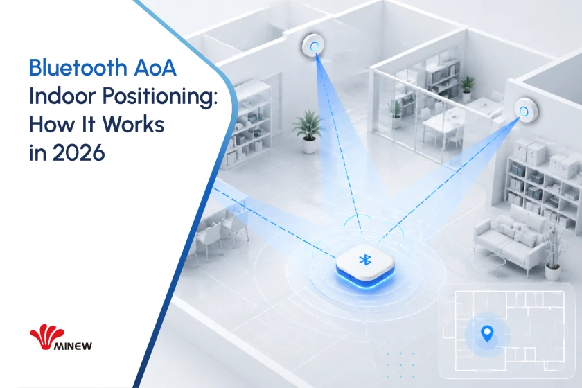
Ángulo de llegada de Bluetooth, comúnmente llamado Bluetooth AoA, aborda esa brecha agregando información de dirección a las señales de Bluetooth de baja energía. Puede soportar precisión, Ubicación en tiempo real manteniendo el factor de forma compacto., bajo consumo de energía, y amplio ecosistema de proveedores asociados a la tecnología Bluetooth.
AoA no es un reemplazo universal para todas las tecnologías de posicionamiento en interiores. Su valor más fuerte proviene del equilibrio.. Para muchos industriales, logística, cuidado de la salud, y edificio inteligente proyectos, Puede ofrecer un rendimiento útil por debajo del metro sin el coste de etiqueta y el perfil de potencia asociados con algunas alternativas de mayor precisión..
La idea central
Bluetooth AoA estima la dirección de una señal de radio. Luego, un motor de posicionamiento combina esa dirección con la geometría del localizador conocida y los datos del sitio para estimar la posición de la etiqueta..
Cómo evolucionó el posicionamiento en interiores
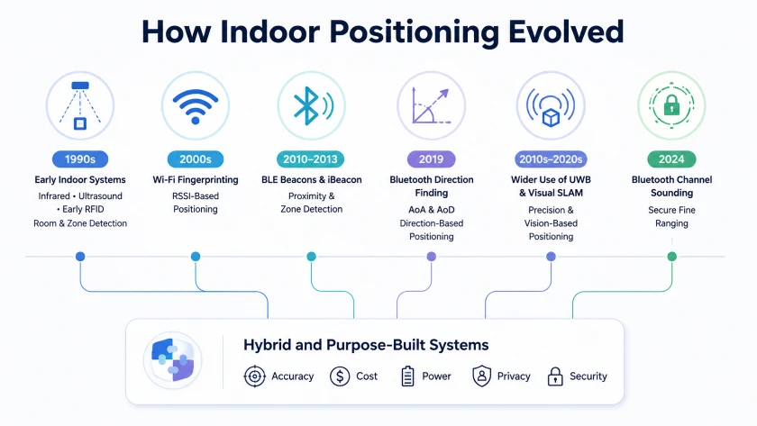
El posicionamiento en interiores no avanzó por un único camino tecnológico. En cambio, Surgieron diferentes enfoques para resolver diferentes problemas., desde la detección básica a nivel de habitación hasta el seguimiento preciso en tiempo real.
Sistemas tempranos: infrarrojo, ultrasonido, y RFID
Algunos de los primeros sistemas de localización en interiores aparecieron en la década de 1990.. El proyecto Insignia Activa en la Universidad de Cambridge utilizaron señales infrarrojas para identificar la habitación en la que se encontraba una persona. Otros sistemas experimentaron con la identificación por ultrasonidos y radiofrecuencia.
Estas tecnologías demostraron que la localización en interiores era posible, pero cada uno tenía limitaciones prácticas. Los infrarrojos requerían una línea de visión relativamente clara. El ultrasonido podría verse afectado por las condiciones ambientales y la infraestructura dedicada requerida. La RFID pasiva fue efectiva para la identificación en puntos de lectura específicos, pero no fue diseñada para uso continuo., seguimiento de todo el edificio.
Adopción más amplia: Wi-Fi y Bluetooth RSSI
A medida que las redes inalámbricas se volvieron comunes, Wifi La intensidad de la señal se convirtió en una fuente práctica de datos de ubicación.. Los sistemas compararon la intensidad de la señal recibida desde múltiples puntos de acceso con modelos de propagación o huellas dactilares de señales recopiladas previamente..
El posicionamiento Wi-Fi hizo que la navegación en interiores y la ubicación de dispositivos fueran más accesibles, pero el rendimiento varió significativamente según la distribución del edificio, movimiento humano, muebles, y condiciones cambiantes de la radio.
Bluetooth Low Energy creó otro cambio importante. Apple presentó iBeacon en 2013, ayudando a popularizar las balizas Bluetooth de bajo coste para servicios de proximidad, detección de zona, y contenido basado en la ubicación. Etiquetas BLE podría funcionar durante largos períodos con baterías pequeñas, lo que hizo que los despliegues a gran escala fueran más prácticos.
Sin embargo, Tanto el posicionamiento Wi-Fi como el BLE convencional dependían en gran medida de la intensidad de la señal recibida.. RSSI puede indicar si un dispositivo probablemente esté cerca o lejos, pero reflexiones, obstrucción, orientación de la antena, y el bloqueo del cuerpo lo convierten en una medida poco confiable de distancia precisa. Por lo tanto, estos sistemas eran más adecuados para aplicaciones de proximidad y a nivel de zona que el seguimiento constante de alta precisión..
Posicionamiento de precisión: medición de dirección y distancia
Un cambio importante llegó con Bluetooth Core 5.1, que introdujo la búsqueda de dirección. En lugar de estimar la ubicación sólo a partir de la intensidad de la señal, Los sistemas compatibles podrían utilizar mediciones del ángulo de llegada o del ángulo de salida para estimar la dirección de la señal..
Posicionamiento submétrico habilitado por Bluetooth AoA en implementaciones diseñadas adecuadamente, aunque el rendimiento real todavía depende de la geometría del localizador, calibración, colocación de etiquetas, y el entorno radiofónico.
Durante el mismo periodo, La banda ultraancha se adoptó en aplicaciones que requerían mediciones de distancia de alta precisión, mientras que SLAM visual se volvió importante para los robots, sistemas de realidad aumentada, y dispositivos equipados con cámaras.
Sonido del canal Bluetooth, introducido en Bluetooth Core 6.0, Se agregaron capacidades seguras de rango fino a la cartera de tecnología Bluetooth.. No reemplaza a AoA. Dirección de las estimaciones del AA, mientras que Channel Sounding estima la distancia. Juntos, Estos avances muestran que el posicionamiento interior moderno está avanzando hacia sistemas híbridos que seleccionan o combinan tecnologías según la precisión requerida., tipo de dispositivo, costo, consumo de energía, privacidad, y entorno operativo.
Qué mide Bluetooth AoA
Búsqueda de dirección por Bluetooth se introdujo como una capacidad opcional en Bluetooth Core 5.1. Define dos métodos., Ángulo de llegada y ángulo de salida. AoA se utiliza comúnmente para sistemas de localización en tiempo real en los que una etiqueta móvil transmite y los localizadores fijos reciben.. AoD invierte la disposición de la antena y a menudo se analiza en el contexto del posicionamiento en interiores basado en dispositivos..
En un sistema AoA, la etiqueta transmite una señal que incluye una extensión de tono constante, o CTE. Un localizador contiene múltiples elementos de antena dispuestos en una matriz.. A medida que la señal cruza la matriz, pequeñas diferencias en la longitud del camino crean diferencias de fase mensurables. El localizador cambia entre elementos de antena., captura muestras en fase y en cuadratura, y utiliza esas muestras para estimar la dirección de la señal.
La dirección por sí sola no siempre es una posición completa. El motor de posicionamiento puede combinar ángulos de múltiples localizadores., altura de montaje, restricciones del mapa, calidad de señalización, y filtrado para calcular una coordenada bidimensional o tridimensional. Un solo localizador puede estimar la dirección, y algunos diseños restringidos pueden derivar una posición a partir de un localizador, pero múltiples localizadores generalmente mejoran la cobertura, redundancia, y resistencia a condiciones fuera de la línea de visión.
Cómo AoA & El sonido del canal difiere
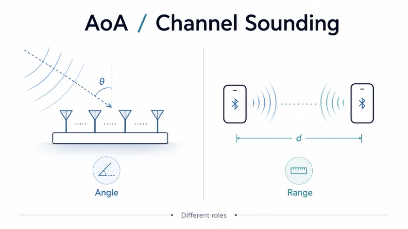
Bluetooth AoA vs sonido de canal Bluetooth son tecnologías de localización relacionadas, pero no deben presentarse como la misma característica.
• AA estima la dirección analizando las diferencias de fase a través de un conjunto de antenas.
• Sonido de canal estima la distancia entre dos dispositivos conectados. Núcleo Bluetooth 6.0 introdujo el sonido de canal con rango basado en fases y métodos opcionales de sincronización de ida y vuelta.
• Núcleo Bluetooth 6.3 Precisión y eficiencia mejoradas del sonido de canal a través de funciones como transferencia PCT en línea e informes de precisión RTT específicos de PHY.. No redefinió directamente el procesamiento de AoA o CTE..
Una solución futura o patentada puede combinar mediciones de ángulos y distancias., y esa combinación puede ser valiosa. Sin embargo, El rendimiento de un sistema híbrido depende de la implementación del producto., diseño de radio, algoritmos, topología, y funciones Bluetooth compatibles. Es más exacto describir AoA y Channel Sounding como herramientas complementarias que afirmar que una mejora automáticamente a la otra..
lo que cambió en 2026
Los estándares y el ecosistema de proveedores son más maduros
La búsqueda de dirección ha estado disponible desde 2019, dando proveedores de chipsets, fabricantes de localizadores, proveedores de etiquetas, y equipos de software de varias generaciones de productos para mejorar el diseño de antenas, calibración, firmware, y algoritmos de localización. Esta madurez es importante porque la precisión es una propiedad del sistema completo., no sólo la radio Bluetooth.
Bluetooth continúa escalando en todas las categorías de dispositivos
Los proyectos Bluetooth SIG acerca de 5.9 mil millones de envíos de dispositivos con Bluetooth en 2026 y más que 8.1 mil millones de envíos anuales por 2030. Estas cifras describen el ecosistema Bluetooth general., no solo la adopción de AoA, pero ayudan a explicar por qué Bluetooth sigue siendo atractivo para infraestructuras de larga duración y estrategias de productos de múltiples proveedores..
La recolección de energía está ampliando las opciones de diseño de etiquetas
El bajo consumo siempre ha sido una gran ventaja de las etiquetas Bluetooth. En 2025 y 2026, Las etiquetas de recolección de luz ambiental disponibles comercialmente agregaron una nueva opción para sitios con iluminación adecuada.. El Etiqueta BLE de recolección de luz ambiental Minew MTB11 está diseñado para funcionar utilizando energía obtenida de la luz ambiental interior y tiene una vida útil estimada de diez años o más en condiciones de iluminación y configuraciones de dispositivo específicas.
La compatibilidad con funciones importa más que las etiquetas de versión
Un dispositivo calificado contra Bluetooth Core 5.1 o una versión principal posterior no admite automáticamente la búsqueda de dirección. La mayoría de Funciones de especificación de Bluetooth son opcionales. Las especificaciones del producto deben indicar explícitamente el soporte para radiogoniometría., Transmisión o recepción CTE, conmutación de antena, y las interfaces de host requeridas.
Precisión de Bluetooth AoA en implementaciones del mundo real
La localización de dirección por Bluetooth puede habilitar sistemas que alcancen una precisión de ubicación de nivel centimétrico, y las implementaciones comerciales optimizadas pueden funcionar muy bien. Al mismo tiempo, una propuesta que promete una precisión de diez centímetros en todas partes suele ser demasiado agresiva. De acuerdo a la investigación del posicionamiento y seguimiento bluetooth, El material Bluetooth SIG y las pruebas de los proveedores enfatizan que el rendimiento depende del sistema completo y del entorno operativo..
Para fines de planificación, Muchos proyectos empresariales de AoA apuntan a una precisión inferior al metro, a menudo alrededor 0.3 a 1 medidor en condiciones bien diseñadas. Algunas instalaciones controladas pueden alcanzar decenas de centímetros o más.. Los resultados reales dependen de varios factores.:
• Geometría del localizador, altura de montaje, campo de visión, y calibración del conjunto de antenas
• Disponibilidad de línea de visión y cantidad de metal., vaso, estantería, maquinaria, y moviendo gente
• Orientación de la etiqueta de seguimiento, bloqueo del cuerpo, embargo de activos, intervalo de transmisión, y transmitir potencia
• Interferencias de radiofrecuencia, sincronización del localizador, latencia de retorno, y posicionamiento del diseño del motor
• La métrica de aceptación, como el error medio, 90error percentil, tasa de actualización, y confiabilidad de la zona
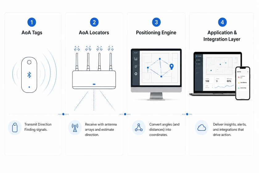
Los cuatro componentes de un sistema Bluetooth AoA
1. etiquetas AA
Las etiquetas están adjuntas a las personas., activos, herramientas, contenedores, o vehículos. Deben soportar el comportamiento de transmisión de localización de dirección requerido., no simplemente publicidad Bluetooth. La selección de etiquetas debe considerar la estrategia de la batería, intervalo de publicidad, clasificación del recinto, detección de movimiento, botones, método de archivo adjunto, y si la etiqueta será bloqueada por un cuerpo o una superficie metálica.
2. Localizadores de AoA
Los localizadores son receptores fijos con conjuntos de antenas.. Captan datos de coeficiente intelectual relacionados con CTE y estiman la dirección de la señal localmente o envían datos de medición a otra capa de procesamiento.. La alimentación a través de Ethernet es común porque combina energía y datos estables., aunque algunos productos utilizan alimentación independiente y backhaul inalámbrico.
3. El motor de posicionamiento
El motor de posicionamiento convierte las medidas de ángulos en coordenadas.. Puede utilizar triangulación., restricciones del mapa, ponderación de la calidad de la señal, Filtrado de Kalman, filtrado de partículas, modelos de movimiento, o calibración específica del entorno. La multilateración es apropiada cuando el motor también utiliza mediciones de distancia., como los de otra tecnología de rango.
4. La capa de aplicación e integración.
Una coordenada se vuelve valiosa solo cuando cambia un flujo de trabajo. La capa de aplicación proporciona mapas., buscar, historia, geocercas, alertas, análisis de utilización, y API. Integración con un sistema de gestión de almacenes., sistema de ejecución de fabricación, plataforma de planificación de recursos empresariales, sistema de gestión de edificios, o plataforma de flujo de trabajo clínico es a menudo donde se crea el valor empresarial.
Dónde funciona mejor Bluetooth AoA
Operaciones industriales y de fabricación.
AoA puede ayudar a localizar herramientas, trabajo en progreso, contenedores retornables, equipo movil, y trabajadores. Los proyectos más sólidos se centran en mejoras mensurables del flujo de trabajo., como reducir el tiempo de búsqueda, evitar que la herramienta incorrecta entre en un proceso, confirmando llegada de material, o activar una alerta cuando una persona ingresa a un área restringida.
Almacenamiento y logística
Palets, jaulas antivuelco, montacargas, inventario de alto valor, y los artículos de transporte reutilizables son objetivos comunes. La ubicación por debajo del medidor puede permitir una recuperación más rápida y transiciones de zona más confiables, mientras que las etiquetas de menor costo pueden hacer que una cobertura más amplia sea económicamente práctica. Los estantes metálicos y la densidad cambiante del inventario requieren pruebas de RF cuidadosas.
Cuidado de la salud
Los hospitales pueden utilizar la ubicación en tiempo real para encontrar equipos médicos móviles, respaldar los flujos de trabajo de seguridad del paciente, y personal de ruta durante eventos urgentes. La precisión es sólo un requisito. Privacidad, control de acceso, retención de datos, control de infecciones, limpieza de etiquetas, y la integración con los sistemas clínicos debe incluirse en el diseño..
Edificios y oficinas inteligentes
AoA puede respaldar la gestión de activos móviles, operaciones espaciales, respuesta de emergencia, y flujos de trabajo de servicios. El seguimiento del personal debe tener un propósito limitado y ser transparente. Las organizaciones deben definir quién puede ver los datos de ubicación, cuanto tiempo se retiene, y qué decisiones se pueden tomar a partir de él.
Lugares públicos y experiencias de visitantes.
Museos, aeropuertos, campus, y los lugares para eventos pueden usar la ubicación Bluetooth para el personal, equipo, analítica, y navegación. AoA se adapta bien al seguimiento de etiquetas basado en infraestructura. La orientación basada en teléfonos inteligentes puede utilizar AoD, RSSI, Wifi, posicionamiento visual, o un enfoque híbrido, dependiendo del soporte real del hardware del teléfono y del sistema operativo.
Bluetooth AoA en comparación con otras tecnologías de posicionamiento
Los valores siguientes son rangos de planificación., especificaciones no garantizadas. Los productos y entornos varían significativamente.
| Tecnología | Resultado típico en interiores | Poder de la etiqueta | Infraestructura | Mejor ajuste | Limitación principal |
| RSSI Bluetooth | Nivel de habitación o zona a varios metros. | muy bajo | Balizas o receptores | Proximidad y visibilidad básica | La intensidad de la señal cambia con el entorno. |
| Bluetooth AoA | A menudo submetro, con mejores resultados en sistemas optimizados | muy bajo | Localizadores de conjuntos de antenas y motor de posicionamiento. | RTLS empresarial a escala | Calibración, condiciones sin línea de visión, y soporte de funciones |
| UWB | A menudo a nivel de decímetro y a veces mejor | Bajo a moderado | Anclas y motor de posicionamiento. | Máxima precisión y alcance seguro | Mayor costo de hardware y potencia en muchos diseños. |
| Wi-Fi RTT | Generalmente a nivel de medidor | Dependiente del dispositivo | Puntos de acceso y clientes compatibles | Posicionamiento centrado en el teléfono inteligente | Soporte al cliente, uso de energía, y coherencia en la implementación |
| RFID | punto de lectura, portal, zona, o identificación de corto alcance | Pasivo o bajo | Lectores y antenas | Flujos de trabajo de inventario y puntos críticos | Muchos diseños no proporcionan coordenadas continuas. |
| Visión o SLAM | Alta precisión en áreas visibles bien mapeadas | Depende de la cámara y la computadora | Cámaras o hardware de visión a bordo | Robótica, realidad aumentada, y mapeo | Oclusión, Encendiendo, privacidad, y calcular la demanda |
Cómo planificar una implementación AoA confiable
Comience con el resultado del negocio
Definir la decisión que debe soportar el sistema de localización. Encontrar una bomba perdida, confirmar que una paleta ingresó a una zona de preparación, y evitar que un trabajador ingrese a un área peligrosa tienen una precisión diferente, estado latente, cobertura, y requisitos de confiabilidad.
Inspeccione el sitio antes de seleccionar la densidad del localizador
Altura del techo de documentos, materiales de pared, estructuras metalicas, estantería, equipo en movimiento, infraestructura electrica, acceso a la red, y áreas de instalación restringidas. No existe un espaciado de localizador universal ni un recuento mínimo de localizadores que se aplique a todos los proyectos de AoA.. Utilice el modelo de cobertura de proveedores como punto de partida, luego validarlo en el entorno real.
Ejecute una prueba de concepto en el área más difícil
No pruebes solo en una sala de conferencias abierta. Prueba los más reflectantes, atestado, o zona operativamente importante. Incluir colocación y movimiento de etiquetas realistas. Medir la distribución del error, actualizaciones perdidas, transiciones de zona, tiempo de recuperación, y comportamiento durante la interrupción de la red.
Diseñe la geometría del localizador para visibilidad y redundancia
Instale localizadores donde el campo de visión de su antena cubra el área de seguimiento y donde sea menos probable que los objetos metálicos grandes bloqueen el camino directo.. El montaje en techo es común, pero la altura y orientación correctas dependen del diseño del localizador y de la geometría del sitio.. Agregue superposición cuando la seguridad o la continuidad del proceso requieran una mayor confiabilidad.
Trate la colocación de etiquetas como parte del diseño de RF
Una etiqueta adherida detrás de una placa de metal o colocada debajo del cuerpo puede funcionar de manera muy diferente a la misma etiqueta en el espacio libre.. Pruebe el recinto final, material de fijación, orientación, y posición del usuario. Configure el intervalo de transmisión y la potencia para equilibrar la tasa de actualización, capacidad de radio, y uso de energía.
Calibrar y definir pruebas de aceptación
Importar un plano de planta preciso, registrar coordenadas y orientación del localizador, y siga el proceso de calibración del proveedor. Cree una ruta de aceptación repetible con puntos de referencia conocidos. Informe el error mediano y percentil en lugar de un único número en el mejor de los casos.
Integrar los datos en un flujo de trabajo
Decide cómo buscarán los usuarios, recibir alertas, reconocer eventos, y cerrar tareas. Definir la propiedad de la API, mapeo de identidad, retención, acceso basado en roles, controles de ciberseguridad, y apoyo operativo. Un punto técnicamente preciso en un mapa no genera retorno de la inversión por sí solo.
Mejores prácticas para la implementación de Bluetooth AoA
Definir requisitos de rendimiento claros
Establezca objetivos mensurables para lograr precisión, tasa de actualización, estado latente, cobertura, capacidad de etiqueta, y disponibilidad del sistema antes de seleccionar el hardware.
Examinar el entorno real
Altura del techo de documentos, estructuras metalicas, estantería, obstrucciones, acceso al poder, disponibilidad de red, y restricciones de instalación.
Pruebe el área más desafiante
Ejecute la prueba de concepto de forma reflexiva., atestado, o área operativamente crítica. Utilice una ubicación de etiquetas realista, movimiento, y condiciones del tráfico.
Optimizar la ubicación del localizador
Siga las instrucciones de instalación del fabricante del localizador.. Mantener una cobertura adecuada, reducir las obstrucciones importantes, y agregar superposición donde se requiere mayor confiabilidad.
Pruebe la colocación final de la etiqueta
Evalúe la etiqueta en su carcasa real y posición de montaje.. Bloqueo corporal, superficies metálicas, orientación, y los materiales de fijación pueden afectar el rendimiento.
Calibrar y verificar el rendimiento
Utilice un plano de planta preciso y registre la posición y orientación de cada localizador.. Mida el rendimiento en puntos de referencia conocidos e informe errores típicos y percentiles.
Integración y mantenimiento del plan
Defina cómo los datos de ubicación ingresarán a los flujos de trabajo comerciales. Incluir integración API, propiedad de los datos, privacidad, ciberseguridad, mantenimiento del dispositivo, y apoyo operativo.
Control de llave
Bluetooth AoA se entiende mejor como una capa de precisión para la ubicación en tiempo real basada en Bluetooth, no como un GPS mágico para interiores. Su valor proviene de combinar etiquetas de bajo consumo., medidas de dirección, infraestructura calibrada, algoritmos de ubicación, e integración del flujo de trabajo.
En 2026, La tecnología es lo suficientemente madura para un despliegue industrial y comercial serio., mientras que Channel Sounding está ampliando el conjunto de herramientas de ubicación de Bluetooth con un rango fino seguro. Equipos que separan claramente estas capacidades, validar el rendimiento en el sitio, y conectar datos de ubicación a operaciones medibles tienen más probabilidades de lograr un resultado sólido.
Para organizaciones que evalúan etiquetas Bluetooth, localizadores, y hardware piloto, Minew puede ayudar a definir una prueba de concepto práctica y seleccionar dispositivos que se adapten al entorno., tasa de actualización, plan de mantenimiento, y necesidades de integración.
 Chatea ahora