


Warum GPS in Innenräumen Probleme hat
Globale Navigationssatellitensysteme funktionieren gut im Freien, da Empfänger Signale von mehreren Satelliten empfangen können. Drinnen, Wände, Decken, Maschinen, Regale, Menschen, und reflektierende Oberflächen schwächen und verzerren diese Signale. Das Ergebnis ist eine bekannte Lücke: Organisationen können ein Fahrzeug über einen Kontinent hinweg verfolgen, aber ich habe immer noch Schwierigkeiten, ein Werkzeug zu finden, medizinisches Gerät, Palette, oder Arbeiter in einem Gebäude.
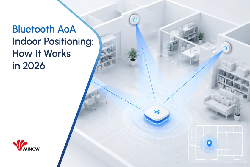
Bluetooth-Ankunftswinkel, allgemein genannt Bluetooth AoA, schließt diese Lücke, indem es den Bluetooth Low Energy-Signalen Richtungsinformationen hinzufügt. Es kann präzise unterstützen, Echtzeit-Standortbestimmung unter Beibehaltung des kompakten Formfaktors, geringer Stromverbrauch, und ein breites Lieferanten-Ökosystem im Zusammenhang mit der Bluetooth-Technologie.
AoA ist kein universeller Ersatz für jede Indoor-Positionierungstechnologie. Sein stärkster Wert ergibt sich aus dem Gleichgewicht. Für viele Industrie, Logistik, Gesundheitspflege, Und Intelligentes Gebäude Projekte, Es kann eine nützliche Leistung im Submeterbereich liefern, ohne dass die Tag-Kosten und das Leistungsprofil anfallen, die mit einigen Alternativen mit höherer Präzision verbunden sind.
Die zentrale Idee
Bluetooth AoA schätzt die Richtung eines Funksignals. Eine Positionierungsmaschine kombiniert dann diese Richtung mit bekannter Ortungsgeometrie und Standortdaten, um die Tag-Position abzuschätzen.
Wie sich die Positionierung in Innenräumen entwickelte
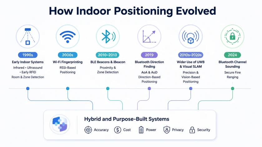
Die Indoor-Ortung hat sich nicht über einen einzigen technologischen Weg weiterentwickelt. Stattdessen, Es entstanden unterschiedliche Ansätze zur Lösung unterschiedlicher Probleme, Von der einfachen Erkennung auf Raumebene bis zur präzisen Echtzeitverfolgung.
Frühe Systeme: Infrarot, Ultraschall, und RFID
Einige der frühesten Indoor-Ortungssysteme kamen in den 1990er Jahren auf den Markt. Das Active Badge-Projekt an der Universität Cambridge nutzten Infrarotsignale, um den Raum zu identifizieren, in dem sich eine Person befand. Andere Systeme experimentierten mit Ultraschall und Radiofrequenzidentifikation.
Diese Technologien zeigten, dass eine Standortbestimmung in Innenräumen möglich ist, aber jedes war mit praktischen Einschränkungen verbunden. Infrarot erforderte eine relativ klare Sichtlinie. Ultraschall kann durch Umgebungsbedingungen und die erforderliche spezielle Infrastruktur beeinträchtigt werden. Passives RFID war für die Identifizierung an bestimmten Lesepunkten wirksam, war jedoch nicht für die kontinuierliche Identifizierung konzipiert, gebäudeweite Nachverfolgung.
Breitere Akzeptanz: Wi-Fi und Bluetooth RSSI
Als drahtlose Netzwerke üblich wurden, W-lan Die Signalstärke wurde zu einer praktischen Quelle für Standortdaten. Die Systeme verglichen die empfangene Signalstärke von mehreren Zugangspunkten mit Ausbreitungsmodellen oder zuvor gesammelten Signalfingerabdrücken.
Die Wi-Fi-Ortung machte die Indoor-Navigation und den Gerätestandort leichter zugänglich, Die Leistung variierte jedoch erheblich je nach Gebäudelayout, menschliche Bewegung, Möbel, und sich ändernde Funkbedingungen.
Bluetooth Low Energy hat einen weiteren wichtigen Wandel bewirkt. Apple hat iBeacon eingeführt 2013, trägt dazu bei, kostengünstige Bluetooth-Beacons für Proximity-Dienste bekannt zu machen, Zonenerkennung, und standortbezogene Inhalte. BLE-Tags könnte mit kleinen Batterien längere Zeit betrieben werden, was groß angelegte Einsätze praktischer machte.
Jedoch, Sowohl die WLAN- als auch die herkömmliche BLE-Ortung waren stark von der Stärke des empfangenen Signals abhängig. RSSI kann anzeigen, ob sich ein Gerät wahrscheinlich in der Nähe oder in der Ferne befindet, sondern Reflexionen, Obstruktion, Antennenausrichtung, und Körperblockierung machen es zu einem unzuverlässigen Maß für die genaue Entfernung. Diese Systeme eigneten sich daher besser für Anwendungen auf Proximity- und Zonenebene als für eine konsistente, hochpräzise Nachverfolgung.
Präzise Positionierung: Richtungs- und Entfernungsmessung
Eine große Änderung kam mit Bluetooth Core 5.1, die die Richtungsfindung einführte. Anstatt den Standort nur anhand der Signalstärke zu schätzen, Kompatible Systeme könnten Messungen des Ankunftswinkels oder des Abflugwinkels verwenden, um die Signalrichtung abzuschätzen.
Bluetooth AoA ermöglichte die Positionierung im Submeterbereich in entsprechend konzipierten Bereitstellungen, Die tatsächliche Leistung hängt jedoch immer noch von der Locator-Geometrie ab, Kalibrierung, Tag-Platzierung, und die Radioumgebung.
Im gleichen Zeitraum, Ultrabreitband hat sich in Anwendungen durchgesetzt, die hochpräzise Abstandsmessungen erfordern, während visuelles SLAM für Roboter wichtig wurde, Augmented-Reality-Systeme, und mit Kameras ausgestattete Geräte.
Bluetooth-Kanalklang, eingeführt in Bluetooth Core 6.0, hat das Bluetooth-Technologieportfolio um sichere Feinbereichsfunktionen erweitert. Es ersetzt nicht AoA. AoA schätzt die Richtung, während Channel Sounding die Entfernung schätzt. Zusammen, Diese Entwicklungen zeigen, dass sich die moderne Indoor-Positionierung hin zu Hybridsystemen entwickelt, die Technologien entsprechend der erforderlichen Genauigkeit auswählen oder kombinieren, Gerätetyp, kosten, Stromverbrauch, Privatsphäre, und Betriebsumgebung.
Was Bluetooth AoA misst
Bluetooth-Peilung wurde als optionale Funktion in Bluetooth Core eingeführt 5.1. Es definiert zwei Methoden, Ankunftswinkel und Abflugwinkel. AoA wird üblicherweise für Echtzeit-Ortungssysteme verwendet, bei denen ein mobiler Tag sendet und feste Ortungsgeräte empfangen. AoD kehrt die Antennenanordnung um und wird oft im Zusammenhang mit der gerätebasierten Indoor-Positionierung diskutiert.
In einem AoA-System, Das Tag sendet ein Signal, das eine Constant Tone Extension enthält, oder CTE. Ein Ortungsgerät enthält mehrere Antennenelemente, die in einem Array angeordnet sind. Wenn das Signal das Array durchquert, Kleine Unterschiede in der Pfadlänge erzeugen messbare Phasenunterschiede. Der Ortungsempfänger schaltet zwischen den Antennenelementen um, erfasst Inphase- und Quadratur-Samples, und nutzt diese Abtastwerte, um die Signalrichtung abzuschätzen.
Die Richtung allein ist nicht immer eine vollständige Position. Die Positionierungs-Engine kann Winkel von mehreren Locators kombinieren, Montagehöhe, Kartenbeschränkungen, Signalqualität, und Filtern, um eine zweidimensionale oder dreidimensionale Koordinate zu berechnen. Ein einzelner Locator kann die Richtung schätzen, und einige eingeschränkte Layouts können eine Position von einem Locator ableiten, aber mehrere Ortungsgeräte verbessern normalerweise die Abdeckung, Redundanz, und Widerstand gegen Bedingungen ohne Sichtverbindung.
Wie AoA & Der Klang des Kanals ist unterschiedlich
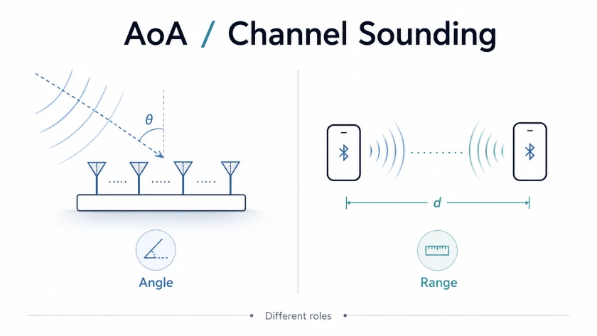
Bluetooth AoA vs. Bluetooth Channel Sounding sind verwandte Ortungstechnologien, Sie sollten jedoch nicht als dasselbe Merkmal dargestellt werden.
• AoA schätzt die Richtung durch Analyse der Phasenunterschiede über ein Antennenarray.
• Kanalklang schätzt die Entfernung zwischen zwei verbundenen Geräten. Bluetooth-Kern 6.0 führte Channel Sounding mit Phase-Based Ranging und optionalen Round-Trip-Timing-Methoden ein.
• Bluetooth-Kern 6.3 Verbesserte Präzision und Effizienz der Kanalbeschallung durch Funktionen wie Inline-PCT-Übertragung und PHY-spezifische RTT-Genauigkeitsberichte. Es hat die AoA- oder CTE-Verarbeitung nicht direkt neu definiert.
Eine zukünftige oder proprietäre Lösung könnte Winkel- und Abstandsmessungen kombinieren, und diese Kombination kann wertvoll sein. Jedoch, Die Leistung eines Hybridsystems hängt von der Produktimplementierung ab, Radiodesign, Algorithmen, Topologie, und unterstützte Bluetooth-Funktionen. Es ist zutreffender, AoA und Channel Sounding als komplementäre Tools zu beschreiben, als zu behaupten, dass das eine das andere automatisch verbessert.
Was sich geändert hat 2026
Die Standards und das Lieferanten-Ökosystem sind ausgereifter
Direction Finding ist seitdem verfügbar 2019, Geben Sie Chipsatz-Anbieter, Hersteller von Ortungsgeräten, Tag-Lieferanten, und Softwareteams mehrere Produktgenerationen, um das Antennendesign zu verbessern, Kalibrierung, Firmware, und Ortungsalgorithmen. Diese Reife ist wichtig, da Genauigkeit eine Eigenschaft des gesamten Systems ist, nicht nur das Bluetooth-Radio.
Bluetooth wächst weiterhin über alle Gerätekategorien hinweg
Die Bluetooth SIG-Projekte um 5.9 Milliarden Bluetooth-fähige Gerätelieferungen im Jahr 2026 und mehr als 8.1 Milliarden jährliche Lieferungen von 2030. Diese Zahlen beschreiben das gesamte Bluetooth-Ökosystem, nicht nur die Einführung von AoA, Aber sie helfen zu erklären, warum Bluetooth für langlebige Infrastrukturen und Multi-Vendor-Produktstrategien weiterhin attraktiv ist.
Energy Harvesting erweitert die Gestaltungsmöglichkeiten für Tags
Der geringe Stromverbrauch war schon immer ein großer Vorteil von Bluetooth-Tags. In 2025 Und 2026, Im Handel erhältliche Umgebungslicht-Ernte-Tags haben eine neue Option für Standorte mit geeigneter Beleuchtung hinzugefügt. Der Minew MTB11 Ambient Light Harvesting BLE-Tag ist für den Betrieb mit Energie aus dem Umgebungslicht in Innenräumen konzipiert und hat unter bestimmten Lichtbedingungen und Gerätekonfigurationen eine geschätzte Lebensdauer von zehn Jahren oder mehr.
Funktionsunterstützung ist wichtiger als Versionsbezeichnungen
Ein für Bluetooth Core qualifiziertes Gerät 5.1 oder eine spätere Kernversion unterstützt Direction Finding nicht automatisch. Die meisten davon Bluetooth-Spezifikationsfunktionen sind optional. In den Produktspezifikationen sollte ausdrücklich die Unterstützung für Direction Finding angegeben werden, CTE-Übertragung oder -Empfang, Antennenumschaltung, und die erforderlichen Host-Schnittstellen.
Bluetooth AoA-Genauigkeit in realen Bereitstellungen
Die Bluetooth-Peilung kann Systeme ermöglichen, die eine Standortgenauigkeit im Zentimeterbereich erreichen, und optimierte kommerzielle Bereitstellungen können eine sehr gute Leistung erbringen. Gleichzeitig, Ein Vorschlag, der überall eine Genauigkeit von zehn Zentimetern verspricht, ist meist zu aggressiv. Entsprechend die Erforschung der Bluetooth-Ortung und -Verfolgung, Bluetooth SIG-Material und Anbietertests betonen beide, dass die Leistung vom Gesamtsystem und der Betriebsumgebung abhängt.
Zu Planungszwecken, Viele AoA-Projekte für Unternehmen zielen auf eine Genauigkeit im Submeterbereich ab, oft in der Nähe 0.3 Zu 1 Messgerät unter gut konzipierten Bedingungen. Einige kontrollierte Installationen können mehrere zehn Zentimeter oder mehr erreichen. Die tatsächlichen Ergebnisse hängen von mehreren Faktoren ab:
• Locator-Geometrie, Montagehöhe, Sichtfeld, und Antennenarray-Kalibrierung
• Sichtlinienverfügbarkeit und Metallmenge, Glas, Regale, Maschinen, und Menschen bewegen
• Tracking-Tag-Ausrichtung, Körperblockierung, Vermögenspfändung, Sendeintervall, und Kraft übertragen
• HF-Störungen, Locator-Synchronisierung, Backhaul-Latenz, und Positionierung des Motordesigns
• Die Akzeptanzmetrik, wie etwa der mittlere Fehler, 90Perzentilfehler, Aktualisierungsrate, und Zonenzuverlässigkeit
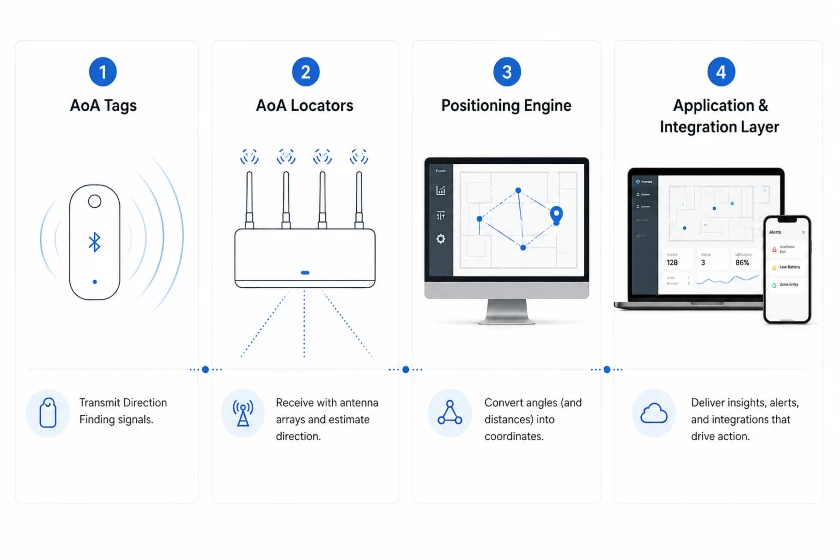
Die vier Komponenten eines Bluetooth-AoA-Systems
1. AoA-Tags
Tags werden an Personen angebracht, Vermögenswerte, Werkzeuge, Behälter, oder Fahrzeuge. Sie müssen das erforderliche Direction Finding-Übertragungsverhalten unterstützen, nicht nur Bluetooth-Werbung. Bei der Tag-Auswahl sollte die Batteriestrategie berücksichtigt werden, Werbeintervall, Gehäusebewertung, Bewegungserkennung, Tasten, Befestigungsmethode, und ob das Etikett durch einen Körper oder eine Metalloberfläche blockiert wird.
2. AoA-Locators
Ortungsgeräte sind fest installierte Empfänger mit Antennenarrays. Sie erfassen CTE-bezogene IQ-Daten und schätzen die Signalrichtung lokal oder senden Messdaten an eine andere Verarbeitungsschicht. Power over Ethernet ist weit verbreitet, da es stabile Stromversorgung und Daten kombiniert, obwohl einige Produkte separate Stromversorgung und drahtloses Backhaul verwenden.
3. Die Positionierungsmaschine
Die Positionierungsmaschine wandelt Winkelmessungen in Koordinaten um. Es kann Triangulation verwenden, Kartenbeschränkungen, Gewichtung der Signalqualität, Kalman-Filterung, Partikelfilterung, Bewegungsmodelle, oder umgebungsspezifische Kalibrierung. Multilateration ist geeignet, wenn die Engine auch Entfernungsmessungen verwendet, beispielsweise solche aus einer anderen Entfernungstechnologie.
4. Die Anwendungs- und Integrationsschicht
Eine Koordinate wird nur dann wertvoll, wenn sie einen Arbeitsablauf verändert. Die Anwendungsschicht stellt Karten bereit, suchen, Geschichte, Geofences, Warnungen, Nutzungsanalyse, und Apis. Integration mit einem Lagerverwaltungssystem, Fertigungsausführungssystem, Plattform für die Planung von Unternehmensressourcen, Gebäudemanagementsystem, Der Geschäftswert wird oft auf der Plattform für klinische Arbeitsabläufe geschaffen.
Wo Bluetooth AoA am besten funktioniert
Fertigungs- und Industriebetriebe
AoA kann bei der Suche nach Werkzeugen helfen, in Arbeit, Mehrwegbehälter, mobile Geräte, und Arbeiter. Die stärksten Projekte konzentrieren sich auf messbare Workflow-Verbesserungen, wie zum Beispiel die Reduzierung der Suchzeit, Verhindert, dass das falsche Werkzeug in einen Prozess gelangt, Bestätigung des Materialeingangs, oder Auslösen einer Warnung, wenn eine Person einen Sperrbereich betritt.
Lagerhaltung und Logistik
Paletten, Überrollkäfige, Gabelstapler, hochwertiges Inventar, und wiederverwendbare Transportgüter sind häufige Ziele. Die Submeter-Ortung kann einen schnelleren Abruf und zuverlässigere Zonenübergänge ermöglichen, während kostengünstigere Etiketten eine größere Abdeckung wirtschaftlich sinnvoll machen können. Metallregale und sich ändernde Lagerdichte erfordern sorgfältige HF-Tests.
Gesundheitspflege
Krankenhäuser können den Standort in Echtzeit nutzen, um mobile medizinische Geräte zu finden, Unterstützung der Arbeitsabläufe zur Patientensicherheit, und Routenpersonal bei dringenden Ereignissen. Genauigkeit ist nur eine Voraussetzung. Privatsphäre, Zugangskontrolle, Datenaufbewahrung, Infektionskontrolle, Tag-Reinigung, und die Integration mit klinischen Systemen muss in das Design einbezogen werden.
Intelligente Gebäude und Büros
AoA kann das mobile Asset Management unterstützen, Weltraumoperationen, Notfallreaktion, und Service-Workflows. Die Personalverfolgung sollte zweckgebunden und transparent sein. Organisationen sollten festlegen, wer Standortdaten sehen kann, wie lange es aufbewahrt wird, und welche Entscheidungen daraus getroffen werden können.
Öffentliche Veranstaltungsorte und Besuchererlebnisse
Museen, Flughäfen, Campus, und Veranstaltungsorte können die Bluetooth-Ortung für Mitarbeiter nutzen, Ausrüstung, Analyse, und Navigation. AoA eignet sich gut für die infrastrukturbasierte Verfolgung von Tags. Bei der Smartphone-basierten Wegfindung kann AoD zum Einsatz kommen, RSSI, W-lan, visuelle Positionierung, oder ein hybrider Ansatz, Abhängig von der tatsächlichen Telefonhardware und der Betriebssystemunterstützung.
Bluetooth AoA im Vergleich zu anderen Positionierungstechnologien
Die folgenden Werte sind Planungsbereiche, keine garantierten Spezifikationen. Produkte und Umgebungen variieren erheblich.
| Technologie | Typisches Indoor-Ergebnis | Tag-Macht | Infrastruktur | Beste Passform | Haupteinschränkung |
| Bluetooth RSSI | Raum- oder Zonenebene bis zu mehreren Metern | Sehr niedrig | Beacons oder Empfänger | Nähe und grundlegende Sichtbarkeit | Die Signalstärke ändert sich mit der Umgebung |
| Bluetooth AoA | Oftmals unter einem Meter, mit besseren Ergebnissen in optimierten Systemen | Sehr niedrig | Antennenarray-Ortungsgeräte und eine Positionierungsmaschine | Unternehmens-RTLS im großen Maßstab | Kalibrierung, Bedingungen ohne Sichtverbindung, und Funktionsunterstützung |
| UWB | Oft auf Dezimeterniveau und manchmal besser | Niedrig bis mäßig | Anker und eine Positionierungsmaschine | Höchste Präzision und sichere Entfernungsmessung | Höhere Hardwarekosten und höhere Leistung in vielen Designs |
| Wi-Fi Rtt | Normalerweise auf Meterebene | Geräteabhängig | Kompatible Access Points und Clients | Smartphone-zentrierte Positionierung | Kundenbetreuung, Stromverbrauch, und Bereitstellungskonsistenz |
| RFID | Punkt lesen, Portal, Zone, oder Nahbereichsidentifikation | Passiv oder niedrig | Lesegeräte und Antennen | Inventarisierungs- und Engpass-Workflows | Viele Designs bieten keine kontinuierlichen Koordinaten |
| Vision oder SLAM | Hohe Präzision in gut kartierten sichtbaren Bereichen | Kamera- und rechnerabhängig | Kameras oder integrierte Bildverarbeitungshardware | Robotik, Augmented Reality, und Kartierung | Okklusion, Beleuchtung, Privatsphäre, und die Nachfrage berechnen |
So planen Sie eine zuverlässige AoA-Bereitstellung
Beginnen Sie mit dem Geschäftsergebnis
Definieren Sie die Entscheidung, die das Standortsystem unterstützen muss. Suche nach einer fehlenden Pumpe, Bestätigung, dass eine Palette in eine Bereitstellungszone gelangt ist, und das Verhindern, dass ein Arbeiter einen Gefahrenbereich betritt, weisen unterschiedliche Genauigkeiten auf, Latenz, Abdeckung, und Zuverlässigkeitsanforderungen.
Vermessen Sie den Standort, bevor Sie die Ortungsdichte auswählen
Deckenhöhe dokumentieren, Wandmaterialien, Metallkonstruktionen, Regale, bewegliche Ausrüstung, elektrische Infrastruktur, Netzwerkzugriff, und eingeschränkte Installationsbereiche. Es gibt keinen universellen Locator-Abstand oder eine Mindest-Locator-Anzahl, die für jedes AoA-Projekt gilt. Nutzen Sie das Anbieterabdeckungsmodell als Ausgangspunkt, Validieren Sie es dann in der realen Umgebung.
Führen Sie einen Proof of Concept im schwierigsten Bereich durch
Führen Sie den Piloten nicht nur in einem offenen Konferenzraum durch. Testen Sie die reflektierendsten, überfüllt, oder betrieblich wichtige Zone. Berücksichtigen Sie realistische Tag-Platzierung und -Bewegung. Messen Sie die Fehlerverteilung, verpasste Updates, Zonenübergänge, Erholungszeit, und Verhalten bei Netzwerkstörungen.
Entwerfen Sie die Locator-Geometrie für Sichtbarkeit und Redundanz
Installieren Sie Ortungsgeräte dort, wo ihr Antennensichtfeld den Ortungsbereich abdeckt und wo große Metallgegenstände den direkten Weg weniger wahrscheinlich blockieren. Deckenmontage ist üblich, Die richtige Höhe und Ausrichtung hängen jedoch vom Design des Ortungsgeräts und der Standortgeometrie ab. Fügen Sie Überschneidungen hinzu, wenn Sicherheit oder Prozesskontinuität eine höhere Zuverlässigkeit erfordern.
Behandeln Sie die Tag-Platzierung als Teil des RF-Designs
Ein Tag, der hinter einer Metallplatte angebracht oder unter dem Körper getragen wird, kann im freien Raum eine ganz andere Leistung erbringen als derselbe Tag. Testen Sie das endgültige Gehäuse, Befestigungsmaterial, Orientierung, und Trägerposition. Konfigurieren Sie das Übertragungsintervall und die Leistung, um die Aktualisierungsrate auszugleichen, Funkkapazität, und Energieverbrauch.
Kalibrieren und definieren Sie Abnahmetests
Importieren Sie einen genauen Grundriss, Zeichnen Sie die Koordinaten und die Ausrichtung des Ortungsgeräts auf, und befolgen Sie den Kalibrierungsprozess des Anbieters. Erstellen Sie eine wiederholbare Akzeptanzroute mit bekannten Referenzpunkten. Geben Sie den Median- und Perzentilfehler anstelle einer einzigen Best-Case-Zahl an.
Integrieren Sie die Daten in einen Workflow
Entscheiden Sie, wie Benutzer suchen, Benachrichtigungen erhalten, Ereignisse anerkennen, und enge Aufgaben. Definieren Sie den API-Eigentum, Identitätszuordnung, Zurückbehaltung, Rollenbasierter Zugriff, Cybersicherheitskontrollen, und operative Unterstützung. Ein technisch korrekter Punkt auf einer Karte allein bringt noch keinen Return on Investment.
Best Practices für die Bluetooth-AoA-Bereitstellung
Definieren Sie klare Leistungsanforderungen
Setzen Sie sich messbare Ziele für die Genauigkeit, Aktualisierungsrate, Latenz, Abdeckung, Tag-Kapazität, und Systemverfügbarkeit vor der Auswahl der Hardware.
Untersuchen Sie die tatsächliche Umgebung
Deckenhöhe dokumentieren, Metallkonstruktionen, Regale, Hindernisse, Stromzugang, Netzwerkverfügbarkeit, und Installationsbeschränkungen.
Testen Sie den anspruchsvollsten Bereich
Führen Sie den Proof of Concept reflektierend durch, überfüllt, oder betriebskritischer Bereich. Verwenden Sie eine realistische Tag-Platzierung, Bewegung, und Verkehrsbedingungen.
Optimieren Sie die Platzierung des Locators
Befolgen Sie die Installationsanweisungen des Herstellers des Ortungsgeräts. Sorgen Sie für eine angemessene Abdeckung, größere Hindernisse reduzieren, und fügen Sie Überlappungen hinzu, wenn eine höhere Zuverlässigkeit erforderlich ist.
Testen Sie die endgültige Tag-Platzierung
Bewerten Sie das Tag in seinem tatsächlichen Gehäuse und seiner Montageposition. Körperblockierung, Metallflächen, Orientierung, und Befestigungsmaterialien können die Leistung beeinträchtigen.
Kalibrieren und überprüfen Sie die Leistung
Verwenden Sie einen genauen Grundriss und notieren Sie die Position und Ausrichtung jedes Locators. Messen Sie die Leistung anhand bekannter Referenzpunkte und melden Sie typische und prozentuale Fehler.
Planen Sie Integration und Wartung
Definieren Sie, wie Standortdaten in Geschäftsabläufe einfließen. Integrieren Sie die API-Integration, Dateneigentum, Privatsphäre, Cybersicherheit, Gerätewartung, und operative Unterstützung.
Wichtige Erkenntnisse
Unter Bluetooth AoA versteht man am besten eine Präzisionsschicht für die Bluetooth-basierte Echtzeitortung, nicht als magisches Indoor-GPS. Sein Wert ergibt sich aus der Kombination von Tags mit geringem Stromverbrauch, Richtungsmessungen, kalibrierte Infrastruktur, Ortungsalgorithmen, und Workflow-Integration.
In 2026, Die Technologie ist ausgereift genug für den ernsthaften industriellen und kommerziellen Einsatz, während Channel Sounding das Bluetooth-Ortungs-Toolkit um eine sichere Feinentfernung erweitert. Teams, die diese Fähigkeiten klar trennen, Validierung der Leistung vor Ort, und Standortdaten mit messbaren Vorgängen zu verknüpfen, werden höchstwahrscheinlich ein starkes Ergebnis erzielen.
Für Organisationen, die Bluetooth-Tags evaluieren, Ortungsgeräte, und Pilot-Hardware, Minew kann dabei helfen, einen praktischen Proof of Concept zu definieren und Geräte auszuwählen, die zur Umgebung passen, Aktualisierungsrate, Wartungsplan, und Integrationsbedarf.
 Jetzt chatten