We have all been there. You are navigating through the city with surgical precision, thanks to the tiny “blue dot” on your smartphone. But the moment you step inside a massive shopping mall, a multi-story warehouse, or an underground parking garage, that dot starts to dance erratically across the screen before coming to a dead halt.
![]()
It is a strange physical paradox. GPS signals can travel over 20,000 kilometers from a satellite in space to your hand, yet they struggle to penetrate a few meters of concrete and steel. Why does this “invisible ceiling” exist, Dan how are modern enterprises using wireless technologies like Bluetooth Hemat Energi (BLE) dan Wi-Fi to reclaim their indoor spaces?
The Physics of Boundaries: Why GPS Reaches Its Limit Indoors
To understand why GPS fails indoors, we have to look at the signal itself. GPS satellites are not high-power broadcasters; in fact, their transmitters operate on 50 watts or less, which is about the same as a standard household lightbulb. By the time that signal reaches Earth, it is incredibly faint, often arriving at levels near the “noise floor.“
1.Signal Attenuation
When these weak microwave signals hit a building, they face immediate “atenuasi” (loss of strength). While wood and standard glass are relatively easy to pass through, modern construction materials are far more hostile.
Low-E Glass: Many modern green buildings use energy-efficient glass with a thin metallic coating. This acts like a “Faraday cage,” reflecting up to 90% of the signal back outside.
Concrete and Steel: A thick concrete floor or a steel-reinforced wall can sap 20-25 dB of signal strength. In simple terms, this means the signal becomes 100 times weaker just by passing through one wall.
 2.The Multipath Effect
Even if some signal leaks inside, it becomes a victim of the “multipath effect.” GPS works by measuring the exact time it takes for a signal to travel from a satellite. In an open field, the path is a straight line. Di dalam ruangan, Namun, the signal bounces off metal shelves, elevator shafts, and tiled floors like echoes in a canyon.
The receiver gets the same signal multiple times with slight delays. This confuses the processor, causing your reported location to “jump” oleh 50 meters or more.
3.The Geometry Problem (DOP)
To get a precise fix, your device needs to see at least four satellites spread out across the sky. This is called good “satellite geometry.” Inside, your view of the sky is restricted to a narrow window or a skylight. When satellites are clustered together in one small patch of visible sky, the mathematical uncertainty (known as Dilution of Precision or DOP) skyrockets. Even a strong indoor signal is useless if the geometry is poor.
4.Itu “Cold Start” Battery Drain
This is where the physics of the signal meets the reality of the hardware. Because indoor signals are so weak and fragmented, a GPS chip must work significantly harder to stay connected.
When a device cannot get a clear “lock,” it enters a “cold start” fase. It must spend several minutes constantly scanning and downloading tiny bits of data (called ephemeris) at a painfully slow speed of 50 bits per second. This high-power search mode can increase battery drain by up to 300% compared to an outdoor fix. Untuk AN IoT location suar that needs to last for years, ini “power hunger” is a deal-breaker, making GPS both physically and economically unfeasible for indoor use.

Searching for the “Gold Standard” of Indoor Positioning
Since GPS is effectively “blind” di dalam ruangan, industry has tested several alternatives.
Posisi Wi-Fi: Wi-Fi is cost-effective as it uses existing infrastructure, but it often relies on “fingerprinting”: manually recording a signal map of the building. These maps are fragile because human bodies and furniture absorb or reflect signals. Any environmental change can ruin accuracy, forcing staff into a slow, expensive cycle of re-calibration.
Ultra-Wideband (UWB): This is the high-precision king, offering accuracy down to 10-30 sentimeter. The catch? It is expensive. The hardware cost for anchors and tags is often too high for massive deployments like tracking 10,000 pallets in a warehouse.
Bluetooth Hemat Energi (Bluetooth LE or BLE): Ini adalah “balanced” winner. It is low-cost and extremely power-efficient, allowing tags to run for years on a single coin cell. Since BLE is built into almost every smartphone, it turns existing mobile devices into powerful tracking infrastructure, drastically lowering the barrier for mass-scale industrial deployment.
Choosing the Right Teknologi: Technology vs. Scenario
Achieving seamless indoor-outdoor visibility requires picking the right technology for the specific environment. Here is the basic comparison:
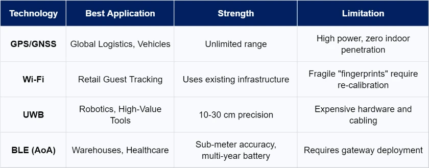
While UWB is the precision king, AoA indoor positioning has emerged as the “balanced” winner for most industrial sites. It provides sub-meter accuracy (0.1 ke 1 meter) and leverages the Bluetooth 5.1 protocol to “melihat” the exact direction of a signal rather than just its volume.
The Power of Multi-Technology Fusion
The modern answer to the “invisible ceiling” is not a single signal, but multi-mode Fusion. Modern hybrid trackers or tags now integrate multiple positioning technologies into a single piece of hardware. You can imagine a smart badge integrating GPS, Wi-Fi scanning, dan BLE for project or facility managers to enhance workflow efficiency dan keselamatan pekerja.
These devices use smart Handover Logic. By utilizing onboard accelerometers or detecting the disappearance of satellite signals, the device automatically shuts down the power-hungry GPS module as it enters a building. It then seamlessly switches to low-power BLE for indoor precision. Ini “scenario-based positioning logic” ensures every bit of battery is used efficiently while maintaining a 100% visible “audit trail” from the highway to the high-shelf.
Real-World Impact: Where RTLS Lives
1.Global Supply Chain
Supply chain “black holes” occur when shipments move from roads into massive warehouses. GPS is vital for long-haul tracking but fails under steel roofs. Hybrid trackers bridge this gap by automatically switching from GPS to BLE indoors. This ensures a continuous visibility trail from the cargo ship to the specific warehouse shelf.
 2.Mass Inventory
Tracking thousands of assets like pallets is impossible if batteries require frequent charging. Standard GPS modules drain power in days. For pure indoor environments, single-technology BLE tags are the champion. These cost-effective devices offer a multi-year battery life, enabling managers to monitor high-volume inventory for a long period without a single battery change.
3.Kesehatan
Nurses in hospitals spend 20% of their time searching for equipment like infusion pumps. Standard Wi-Fi only provides broad zone data. High-precision AoA indoor positioning solves this by seeing the exact signal direction di dalam SMART HeAlTHCARe. This sub-meter accuracy helps locate life-saving tools in seconds, improving both operational efficiency and safety.
4.Industrial Safety & Itu “Transition Zone” Risk
Heavy industrial sites face safety risks in “transition zones” where workers move between outdoor yards and indoor plants. GPS is reliable outside but fails inside metal buildings. Fusion hardware combines GPS and BLE to maintain geofencing alerts everywhere. If a worker enters a dangerous indoor zone, the system triggers an instant alert, memberikan 100% safety coverage.
5.Automotive Assembly: Process Enforcement
High-speed assembly lines require absolute precision. Standard Bluetooth is too broad to verify if a tool is over the correct vehicle. UWB provides 10-30 cm accuracy, ensuring a smart torque tool only unlocks when it is physically over the correct bolt. This enforcement prevents million-dollar errors that lower-precision systems cannot detect.
Kesimpulan: Matching the Tool to the Journey
While a single signal is often enough for focused operational needs, the most ambitious tracking journeys rely on a technical relay race. Global GPS provides scale for transit, while high-precision AoA indoor positioning and UWB deliver the granular detail needed inside walls.
The future belongs to Indoor-outdoor integrated positioning. This is achieved through Multi-technology Fusion, automatically switching from power-hungry GPS to low-power BLE or Wi-Fi scanning the moment an asset enters a facility. This environment-aware handoff preserves battery life for years while keeping your data continuous from the port to the pallet.
Are you ready for total domain visibility?
Stop letting the physical layout of your facility dictate the limits of your data. Our integrated hardware ecosystem, ranging from ultra-accurate UWB anchors to long-life hybrid trackers and tags, is built to solve the complexity of mixed-environment tracking. Explore our hardware solutions today and ensure your “blue dot” never goes dark, no matter where the journey leads.
 Ngobrol sekarang